The Problem
The Oregon Department of Land Conservation and Development (DLCD) was leading a multi-agency Natural Hazards Risk Assessment upgrade involving Oregon Emergency Management, DOGAMI, and counties statewide, funded by FEMA. The project lead had selected PROMETHEE, a rigorous multi-criteria decision-making method, as the analytical foundation for a new methodology and web tool for local planners.
Two challenges shaped the engagement: Running PROMETHEE at near census-block scale across all of Oregon required high-performance computing well beyond what a standard implementation could handle, and communicating a mathematically complex method clearly to the range of stakeholders was critical to the project’s success.
DLCD contracted Northwest Mathematics for the combination of technical computing expertise needed to make PROMETHEE work at scale along with the ability to make a technically complex method intelligible to the stakeholders the project depended on.
How We Worked Together
The engagement began with a discovery phase to understand the full scope of the problem: the PROMETHEE method itself, the disparate hazard datasets that needed to be unified, the scale requirements, and the organizational context including the stakeholder dynamics that were potential barriers to success.
On the technical side, NWM developed a parallel implementation of PROMETHEE in Julia, using the H3 geospatial indexing system to process disparate hazard data into a unified format suitable for statewide analysis. The work was prototyped on Lane County, validated against requirements, then scaled to all Oregon counties. The final phase included working directly with DLCD’s team as they tested the implementation across counties, answering questions and making adjustments until they had full confidence in the tool and could run it independently.
On the organizational side, NWM played a key role in helping multiple audiences understand clearly the PROMETHEE method and overall approach: The DLCD staff leading the project, the visualization team responsible for final app development, and various other stakeholders from other agencies.
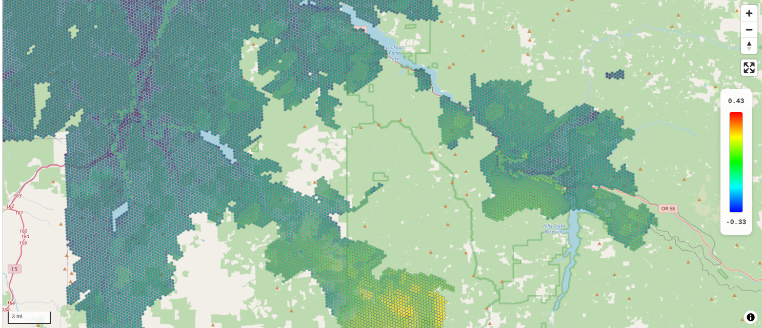
H3 hexagonal geospatial visualization of PROMETHEE risk scores for Lane County.
The Outcome
Northwest Mathematics delivered a performant software implementation that fed directly into DLCD’s existing visualization infrastructure, along with the technical reports and code for DLCD to use and maintain independently.
DLCD came away with a solution they can build upon going forward, a clear and communicable understanding of the analytical method underlying it, and a completed multi-agency project that advances the state of the art in emergency planning in Oregon.